
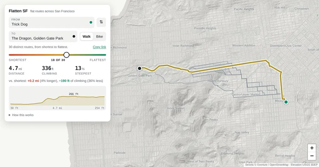
Find the flattest route between any two points in SF
How this works Routes are computed in your browser over 160,000 street segments, using USGS 1 m lidar elevation and the Overture / OpenStreetMap street graph. The slider runs along the whole trade-off between distance and climbing: every route that nothing else beats on both counts, from the shortest path to the flattest one worth walking (where a foot of climb costs 200 ft of walking; beyond that the routes stop being routes). Sliding right never shortens the route and never adds climbing.
- ▪How this works Routes are computed in your browser over 160,000 street segments, using USGS 1 m lidar elevation and the Overture / OpenStreetMap street graph.
- ▪The slider runs along the whole trade-off between distance and climbing: every route that nothing else beats on both counts, from the shortest path to the flattest one worth walking (where a foot of climb costs 200 ft of walking; beyond tha
- ▪Sliding right never shortens the route and never adds climbing.
Hacker News (Front Page) files mainly under programming. We currently carry 2,510 of its stories. Top-voted stories on Hacker News.
Story provenance
Source · retrieval · rights · ranking — open for full record
inspect →
Story provenance
Attribution is not the same as permission. This drawer separates discovery metadata, excerpts, WeSearch-generated summaries, reuse status, and whether the publisher receives the visit. Nothing here claims a legal grant the publisher has not made.
Record
| Original publisher | Flatten SF |
| Canonical URL | https://flattensf.com/ |
| Publication time | Mon, 05 Oct 2026 21:40:50 +0000 |
| Retrieval time | 2026-10-05T22:11:55.689Z |
| Last seen | 2026-10-05T22:11:55.689Z |
| Headline source | Publisher (no WeSearch rewrite) |
| Excerpt source | publisher body |
| Excerpt method | First ~120 words (~800 chars) of extracted publisher body, fair-use limited. |
| Summary | WeSearch · cerebras-chat (WeSearch summarizer) |
| Summary source text | contentText |
| Citation coverage | Summary is a WeSearch-generated derivative; primary citation is the original publisher URL. |
| Cluster | a4H_HGICv1K_ · 1 stories |
| Cluster logic | Grouped by semantic title/content similarity across sources within a rolling window. Same-publisher template collisions are excluded from coverage comparison. |
| Ranking reason | Story pages are not engagement-ranked. Hub feeds use recency, with optional source-diversified chronological ordering (cap consecutive stories per source). No personalized ranking. |
| Publisher visit | Yes — open original |
| Substitutes article? | No — link-out required for full text |
Rights status (four layers)
WeSearch handling by dimension
| Indexing | May the item be indexed (stored, ranked, made findable)? | Allowed |
| Snippet | May a short excerpt of the publisher's text be shown? | Allowed |
| AI summary | May WeSearch generate its own short summary of the article? | Limited |
| Retrieval / RAG | May the content be exposed for third-party retrieval-augmented generation? | Not asserted |
| Model training | May the content be used to train AI models? | Not asserted |
| Commercial reuse | May the content be reused commercially? | Not permitted |
Basis: Derived from the published RSS/Atom feed. Contact: [email protected]. Reviewed: 2026-07-24.
Opening excerpt (first ~120 words) tap to expand
How this works Routes are computed in your browser over 160,000 street segments, using USGS 1 m lidar elevation and the Overture / OpenStreetMap street graph. The slider runs along the whole trade-off between distance and climbing: every route that nothing else beats on both counts, from the shortest path to the flattest one worth walking (where a foot of climb costs 200 ft of walking; beyond that the routes stop being routes). Sliding right never shortens the route and never adds climbing. Climbing is cumulative gain, not the net difference between the endpoints. Stairways are allowed on foot and excluded on a bike. Faint lines show the other routes along the way. Place search is offline: street intersections, places and addresses for San Francisco are built into this page.
…
Excerpt limited to ~120 words for fair-use compliance. The full article is at Flatten SF.
Discussion
0 commentsMore from Flatten SF


