
NYC Commute POV
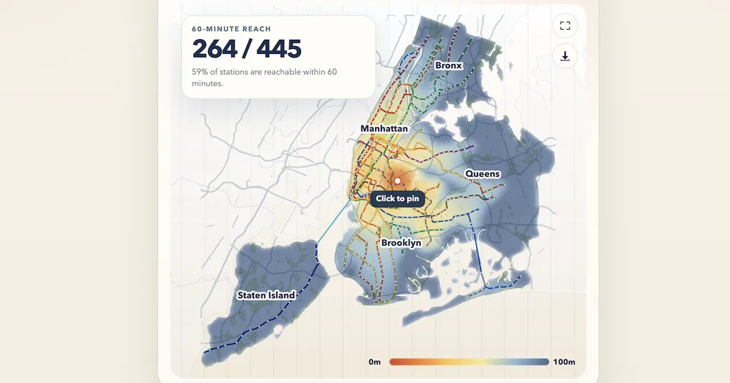
A new interactive tool allows users to visualize subway commute times in New York City. By selecting an origin point on the map, users can see how much of the subway network is accessible within an hour. The tool includes features for adjusting settings and saving locations for future reference.
- ▪Users can touch and drag on the map to generate a heatmap of subway accessibility.
- ▪The tool allows users to measure commute times from any chosen origin point.
- ▪It includes options to save settings and share locations.
Hacker News (Newest) files mainly under programming. We currently carry 5,306 of its stories.
Story provenance
Source · retrieval · rights · ranking — open for full record
inspect →
Story provenance
Attribution is not the same as permission. This drawer separates discovery metadata, excerpts, WeSearch-generated summaries, reuse status, and whether the publisher receives the visit. Nothing here claims a legal grant the publisher has not made.
Record
| Original publisher | NYC Commute POV |
| Canonical URL | https://castrio.me/nyc/ |
| Publication time | Mon, 18 May 2026 11:51:37 +0000 |
| Retrieval time | 2026-05-18T12:04:56.488Z |
| Last seen | 2026-05-18T12:04:56.488Z |
| Headline source | Publisher (no WeSearch rewrite) |
| Excerpt source | publisher body |
| Excerpt method | First ~120 words (~800 chars) of extracted publisher body, fair-use limited. |
| Summary | WeSearch · cerebras-chat (WeSearch summarizer) |
| Summary source text | contentText |
| Citation coverage | Summary is a WeSearch-generated derivative; primary citation is the original publisher URL. |
| Cluster | MRgry8towkHK |
| Cluster logic | Grouped by semantic title/content similarity across sources within a rolling window. Same-publisher template collisions are excluded from coverage comparison. |
| Ranking reason | Story pages are not engagement-ranked. Hub feeds use recency, with optional source-diversified chronological ordering (cap consecutive stories per source). No personalized ranking. |
| Publisher visit | Yes — open original |
| Substitutes article? | No — link-out required for full text |
Rights status (four layers)
WeSearch handling by dimension
| Indexing | May the item be indexed (stored, ranked, made findable)? | Allowed |
| Snippet | May a short excerpt of the publisher's text be shown? | Allowed |
| AI summary | May WeSearch generate its own short summary of the article? | Limited |
| Retrieval / RAG | May the content be exposed for third-party retrieval-augmented generation? | Not asserted |
| Model training | May the content be used to train AI models? | Not asserted |
| Commercial reuse | May the content be reused commercially? | Not permitted |
Basis: Derived from the published RSS/Atom feed. Contact: [email protected]. Reviewed: 2026-07-24.
Opening excerpt (first ~120 words) tap to expand
Commute-time warp Loading transit network… Settings warp heatmap outline Maximum transit time 60 min Reset defaults Save How It Works Touch and drag anywhere on the map to generate your heatmap. Touch again to measure commute time. Pins can be dragged to reposition them. 60-Minute Reach -- / -- Choose an origin to see how much of the subway you can reach in an hour. Use My Location Share... 0m 80m Map controls Mobile Origin Tap the map to place an origin Tap anywhere on the map to pin your starting point, then search, share, or adjust layers from here. Clear 60-Minute Reach -- / -- Choose an origin to see how much of the subway you can reach in an hour.
…
Excerpt limited to ~120 words for fair-use compliance. The full article is at NYC Commute POV.
Discussion
0 commentsMore from NYC Commute POV