Journalists are pairing satellite and AI to expose illegal mining in the Amazon
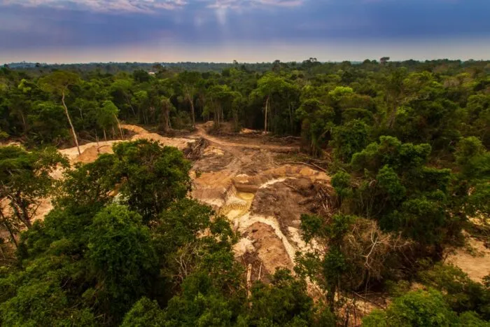
Joseph Poliszuk, a Venezuelan journalist in exile, used satellite imagery and AI to investigate illegal gold mining in the Amazon after being forced to flee his country. He developed a machine learning model to identify thousands of mining sites in Venezuela, some located in protected areas, and linked them to criminal organizations. His work, part of a growing trend in environmental journalism, demonstrates how remote sensing and AI can overcome the dangers and limitations of on-the-ground reporting in remote regions.
- ▪Joseph Poliszuk fled Venezuela in 2018 after exposing corruption and faced threats from Maduro loyalists.
- ▪With support from the Pulitzer Center and Earth Genome, Poliszuk used AI to identify 3,718 illegal gold mining sites in Venezuela's Amazonas and Bolívar states.
- ▪Some of the mining operations were located in protected indigenous lands and Canaima National Park, and were linked to Venezuelan, Colombian, and Brazilian criminal groups.
Hacker News (Front Page) files mainly under programming. We currently carry 710 of its stories. Top-voted stories on Hacker News.
Story provenance
Source · retrieval · rights · ranking — open for full record
inspect →
Attribution is not the same as permission. This drawer separates discovery metadata, excerpts, WeSearch-generated summaries, reuse status, and whether the publisher receives the visit. Nothing here claims a legal grant the publisher has not made.
Record
| Original publisher | Nieman Lab |
| Canonical URL | https://www.niemanlab.org/2026/04/geospatial-ai-is-reinventing-the-rainforest-beat/ |
| Publication time | Tue, 28 Apr 2026 12:02:02 +0000 |
| Retrieval time | 2026-04-28T12:09:31.908Z |
| Last seen | 2026-04-28T12:09:31.908Z |
| Headline source | Publisher (no WeSearch rewrite) |
| Excerpt source | publisher body |
| Excerpt method | First ~120 words (~800 chars) of extracted publisher body, fair-use limited. |
| Summary | WeSearch · cerebras-chat (WeSearch summarizer) |
| Summary source text | contentText |
| Citation coverage | Summary is a WeSearch-generated derivative; primary citation is the original publisher URL. |
| Cluster | wSV1SMsgVZFP |
| Cluster logic | Grouped by semantic title/content similarity across sources within a rolling window. Same-publisher template collisions are excluded from coverage comparison. |
| Ranking reason | Story pages are not engagement-ranked. Hub feeds use recency, with optional source-diversified chronological ordering (cap consecutive stories per source). No personalized ranking. |
| Publisher visit | Yes — open original |
| Substitutes article? | No — link-out required for full text |
Rights status (four layers)
WeSearch handling by dimension
| Indexing | May the item be indexed (stored, ranked, made findable)? | Allowed |
| Snippet | May a short excerpt of the publisher's text be shown? | Allowed |
| AI summary | May WeSearch generate its own short summary of the article? | Limited |
| Retrieval / RAG | May the content be exposed for third-party retrieval-augmented generation? | Not asserted |
| Model training | May the content be used to train AI models? | Not asserted |
| Commercial reuse | May the content be reused commercially? | Not permitted |
Basis: Derived from the published RSS/Atom feed. Contact: [email protected]. Reviewed: 2026-07-24.
Opening excerpt (first ~120 words) tap to expand
In 2018, Joseph Poliszuk fled Venezuela. That year, after exposing corruption in then-President Nicolas Maduro’s administration, he had become the target of lawsuits by wealthy Maduro loyalists. He and several of his colleagues at the independent outlet Armando.info packed up their lives and fled the country under threat of imprisonment. For years, Poliszuk had published stories on Southern Venezuela, which is made up of sparsely populated states that cover large swaths of the Amazon Basin and the Orinoco River Basin. Through field reporting, Poliszuk had exposed illegal gold mines, narcotrafficking operations, and crimes against indigenous groups scattered throughout the region’s rainforests.
…
Excerpt limited to ~120 words for fair-use compliance. The full article is at Nieman Lab.
Discussion
0 commentsMore from Nieman Lab