Full moon helps paint vibrant, muddy 'brushstrokes' in Indonesian river — Earth from space
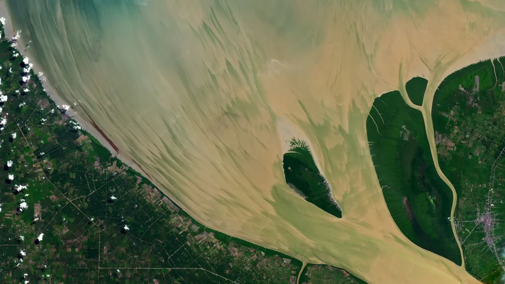
A satellite image from June 2024 shows striking 'brushstroke-like' sediment patterns at the mouth of Indonesia's Rokan River. The patterns were created by a high tide following the full 'Strawberry Moon,' which amplified tidal forces. The Landsat 8 satellite captured the river's estuary as it discharged sediment-laden water into the Strait of Malacca.
- ▪The Rokan River is approximately 220 miles (350 km) long and flows through Sumatra, Indonesia.
- ▪The image was captured by the Landsat 8 satellite on June 23, 2024, during an exceptionally high tide.
- ▪The high tide was caused by a spring tide following the full 'Strawberry Moon,' which occurs when the sun and moon align.
- ▪Sediment in the river, stirred by tidal movements, creates colorful, brushstroke-like patterns visible from space.
- ▪The Rokan River often appears yellow due to high levels of sand and silt in its waters.
Live Science files mainly under science. We currently carry 137 of its stories.
Story provenance
Source · retrieval · rights · ranking — open for full record
inspect →
Attribution is not the same as permission. This drawer separates discovery metadata, excerpts, WeSearch-generated summaries, reuse status, and whether the publisher receives the visit. Nothing here claims a legal grant the publisher has not made.
Record
| Original publisher | Live Science |
| Canonical URL | https://www.livescience.com/planet-earth/rivers-oceans/full-moon-helps-paint-vibrant-muddy-brushstrokes-in-indonesian-river-earth-from-space |
| Publication time | Tue, 28 Apr 2026 10:30:43 +0000 |
| Retrieval time | 2026-04-28T10:41:57.754Z |
| Last seen | 2026-04-28T10:41:57.754Z |
| Headline source | Publisher (no WeSearch rewrite) |
| Excerpt source | publisher body |
| Excerpt method | First ~120 words (~800 chars) of extracted publisher body, fair-use limited. |
| Summary | WeSearch · cerebras-chat (WeSearch summarizer) |
| Summary source text | contentText |
| Citation coverage | Summary is a WeSearch-generated derivative; primary citation is the original publisher URL. |
| Cluster | 3Toj6WF0fiHK |
| Cluster logic | Grouped by semantic title/content similarity across sources within a rolling window. Same-publisher template collisions are excluded from coverage comparison. |
| Ranking reason | Story pages are not engagement-ranked. Hub feeds use recency, with optional source-diversified chronological ordering (cap consecutive stories per source). No personalized ranking. |
| Publisher visit | Yes — open original |
| Substitutes article? | No — link-out required for full text |
Rights status (four layers)
WeSearch handling by dimension
| Indexing | May the item be indexed (stored, ranked, made findable)? | Allowed |
| Snippet | May a short excerpt of the publisher's text be shown? | Allowed |
| AI summary | May WeSearch generate its own short summary of the article? | Limited |
| Retrieval / RAG | May the content be exposed for third-party retrieval-augmented generation? | Not asserted |
| Model training | May the content be used to train AI models? | Not asserted |
| Commercial reuse | May the content be reused commercially? | Not permitted |
Basis: Derived from the published RSS/Atom feed. Contact: [email protected]. Reviewed: 2026-07-24.
Opening excerpt (first ~120 words) tap to expand
Planet Earth Rivers & Oceans Full moon helps paint vibrant, muddy 'brushstrokes' in Indonesian river — Earth from space A 2024 satellite snap shows suspended sediments streaking across the mouth of the Rokan River, thanks in part to a particularly high tide caused by a full "Strawberry Moon." By Harry Baker published 28 April 2026 in Features When you purchase through links on our site, we may earn an affiliate commission. Here’s how it works. Th Landsat 8 satellite spotted a series of "brushstroke-like patterns" in the mouth of the Rokan River, which were painted by an extremely high tide.
…
Excerpt limited to ~120 words for fair-use compliance. The full article is at Live Science.
Discussion
0 commentsMore from Live Science